


Greendale Voting District, Washington County, Virginia
About
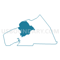
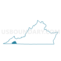
Outline

Summary
| Unique Area Identifier | 682682 |
| Name | Greendale Voting District |
| County | Washington County |
| State | Virginia |
| Area (square miles) | 80.56 |
| Land Area (square miles) | 80.18 |
| Water Area (square miles) | 0.39 |
| % of Land Area | 99.52 |
| % of Water Area | 0.48 |
| Latitude of the Internal Point | 36.76888270 |
| Longtitude of the Internal Point | -82.02798690 |
Maps

Graphs
Select a template below for downloading or customizing gragh for Greendale Voting District, Washington County, Virginia


Neighbors
Neighoring Voting District (by Name) Neighboring Voting District on the Map
- Burson Place Voting District, Washington County, VA
- Clinchburg Voting District, Washington County, VA
- East Abingdon Voting District, Washington County, VA
- East Lebanon Voting District, Russell County, VA
- Hayter's Gap Voting District, Washington County, VA
- John Battle Voting District, Washington County, VA
- Meadowview Voting District, Washington County, VA
- Mendota Voting District, Washington County, VA
- Moccasin Voting District, Russell County, VA
- Wallace Voting District, Washington County, VA
- West Abingdon Voting District, Washington County, VA
Top 10 Neighboring County Subdivision (by Population) Neighboring County Subdivision on the Map
- Lebanon district, Russell County, VA (14,477)
- Harrison district, Washington County, VA (8,733)
- Monroe district, Washington County, VA (7,827)
- Wilson district, Washington County, VA (7,763)
- Jefferson district, Washington County, VA (7,584)
- Tyler district, Washington County, VA (7,233)
Top 10 Neighboring Place (by Population) Neighboring Place on the Map
Top 10 Neighboring Unified School District (by Population) Neighboring Unified School District on the Map
Top 10 Neighboring State Legislative District Lower Chamber (by Population) Neighboring State Legislative District Lower Chamber on the Map
- State House District 4, VA (73,375)
- State House District 1, VA (72,324)
- State House District 2, VA (69,063)
Top 10 Neighboring State Legislative District Upper Chamber (by Population) Neighboring State Legislative District Upper Chamber on the Map
Top 10 Neighboring 111th Congressional District (by Population) Neighboring 111th Congressional District on the Map
Top 10 Neighboring Census Tract (by Population) Neighboring Census Tract on the Map
- Census Tract 103, Washington County, VA (6,949)
- Census Tract 101, Washington County, VA (6,906)
- Census Tract 304.01, Russell County, VA (5,682)
- Census Tract 303, Russell County, VA (4,018)
- Census Tract 105.01, Washington County, VA (3,812)
- Census Tract 104.02, Washington County, VA (3,238)
- Census Tract 106.02, Washington County, VA (2,748)